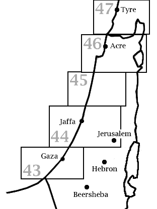
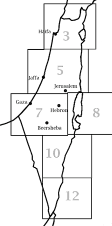
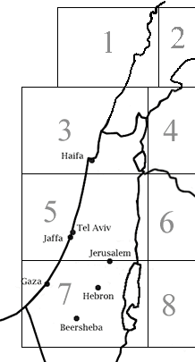
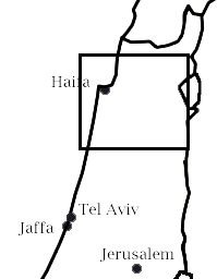
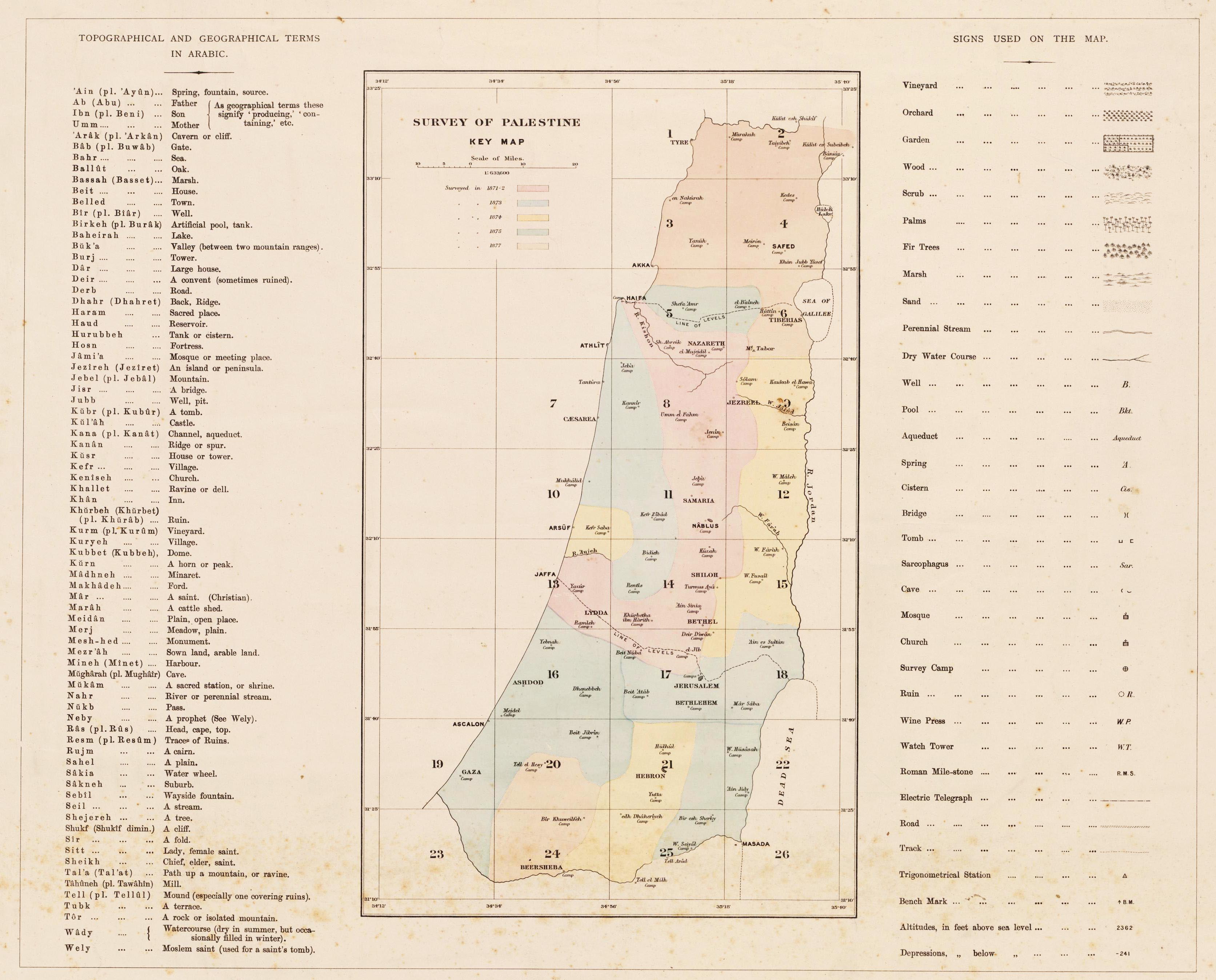
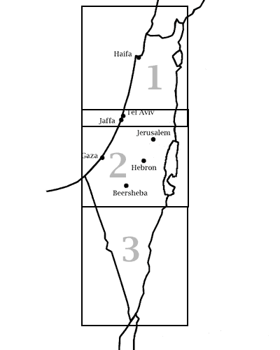
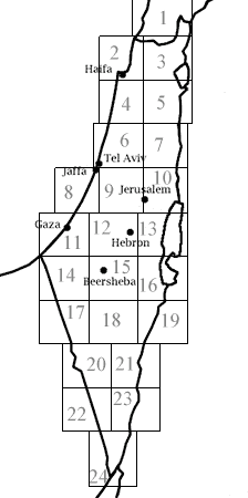
Detailed maps of Palestine

Brendan McKay (last edition May 17, 2012)

On this page we will present a few samples of important maps of Palestine from before 1948, focussing on items that are less easy to find and those which are detailed. Everything here is out of copyright unless otherwise indicated.

Jacotin map (1799)


Pierre Jacotin (1765-1827) was a surveyer and geographer who accompanied Napoleon on his "expedition" to Palestine in 1799. This version of the resulting map was published in 1826 in the atlas "Description de l'Egypte ou recueil des observations et des recherches qui ont ete faites en Egypte pendant l'Expedition de l'Armee francaise. Seconde edition. Dediee au Roi. Publiee par C.L.F. Panckoucke, Chevalier de la Legion d'Honneur. Atlas geographique. Paris, Imprimerie de C.L.F. Panckoucke".

Publication of the map was delayed by more than a decade because Napoleon considered it to be a state secret.

The scale is 1:100,000.

Click on the sheet numbers to see the full maps.

Our source is the amazing David Rumsey historical map collection.

Zimmermann map (1850)


This map was published by Carl Zimmermann, Atlas von Palaestina und der Sinai-Halbinsel, Verlag von Dietrich Reimer, Berlin, 1850.

The scale is 1:333,333.

Click on the sheet numbers to see the full maps.

Our source is the Jewish National and University Library's large collection of Holy Land Maps. There was another edition in 1861, but we don't have it.

Map 1 Map 2 Map 3 Map 4 Map 5 Map 6 Map 7 Map 8

Van de Velde map (1858)


This map was published by Dutch explorer Charles W. M. van de Velde.

The scale is 1:315,000.

Click on the sheet numbers to see the full maps.

Maps 6 and 8 have closer views of Jerusalem.

Our source is the Library of the Vrije Universitet Amsterdam.

An 1865 edition of the map is here.

Mieulet-Derrien map (1870)


A French project to survey all of Palestine with modern techniques was commenced in 1870 by Capitaines d'Etat-Major Mieulet and Derrien. After a short time it was recalled to France when Napoleon III declared war on Prussia. The only sheet produced was this map of the Galilee.

The scale is 1:100,000.

Click on the rectangle to see the full map.

This copy is held in the National Library of France.

Palestine Exploration Fund map (1871-1877)


The Survey of Western Palestine was a project of the Palestine Exploration Fund. Its maps of Palestine were the first large scale (1 inch per mile) maps which were produced with modern surveying methods and aimed to include all major features.

Click on the sheet numbers to see the full maps. You can also click on the left side of the image to see a larger view of this index that includes a glossary of Arabic names and a key to symbols.

Click on the right edge of the image to see a map of a portion of Transjordan to the right of sheet 18.

In addition to the maps several detailed volumes of description were published. Some are presented here.

Survey of Palestine map (1944)


The British mandatory authorities in Palestine prepared a multi-volume survey of Palestine for the Anglo-American Committee of Enquiry, which met in 1946 to discuss the future of Palestine. We scanned this map from a printed edition of the survey.

The scale is 1:250,000.

Click on the sheet numbers to see the full maps.

There is also a list of new Jewish localities established between the map preparation and November 1, 1946.

Topographic maps (1942-1958)


During the British Mandate period, the Survey of Palestine produced several series of topographic maps in various scales. After 1948, the Survey of Israel republished the British maps with overprinting of new information in a purple colour. New settlements are indicated by purple circles with Hebrew names. Arab villages which were depopulated during the 1948 war are marked "(הרוס)" (destroyed). Maps 1–16 are in that series. Israel then began to create new maps entirely in Hebrew starting at the south. Many of the place names were newly invented to replace the previous Arabic names. Maps 17–24 are in that series.

The scale is 1:100,000.

Click on the sheet numbers to see the full maps.

A classified index to all place names that appear on the 1:100,000 maps (not necessarily the exact versions shown here) was published a few times under the name of Palestine Index Gazetteer. The 1948 edition is available at the University of Melbourne. A copy of the transliteration scheme used for Arabic names is available here.

Maps at the higher resolution 1:20,000 can be viewed at the National Library of Israel. To determine the map number for a location, take the first two digits of the grid reference. For example, location 127/202 is in map 12/20.

Back to Middle East Yabber